Eastern European part. East European Plain - main characteristics
The East European or Russian Plain is one of the largest in the world: from north to south it stretches for 2.5 thousand km; from west to east - 1 thousand km. In size, the Russian Plain is second only to the Amazon, located in Western America.
East European Plain - location
From the name it is clear that the plain is located in the East of Europe, and most of it extends into Russia. In the northwest, the Russian Plain runs through the Scandinavian mountains; in the southwest - along the Sudetes and other European mountain ranges; from the West the border is the river. Vistula; on the south-eastern side the border is the Caucasus; in the East - the Urals. In the North, the plain is washed by the White and Barents Seas; in the South - the waters of the Black, Azov and Caspian seas.
East European Plain - relief
The main type of relief is gently flat. Big cities and, accordingly, the bulk of the population of the Russian Federation is concentrated on the territory of the East European Plain. The Russian state was born on these lands. Minerals and other valuable natural resources are also found within the Russian Plain. The outlines of the Russian Plain practically repeat the outlines of the East European Platform. Thanks to such an advantageous location, there is no seismic hazard or likelihood of earthquakes. On the territory of the plain there are also hilly areas that appeared as a result of various tectonic processes. There are elevations up to 1000 m.
In ancient times, the Baltic shield platform was located in the center of glaciation. As a result, there is a glacial relief on the surface.
The terrain consists of lowlands and hills, because... The platform deposits are located almost horizontally.
In places where the folded foundation protruded, ridges (Timansky) and hills (Central Russian) formed.
The height of the plain above sea level is approximately 170 m. The lowest areas are located on the coast of the Caspian Sea. 

East European Plain - glacier influence
Glaciation processes significantly influenced the relief of the Russian Plain, especially in its northern part. A glacier passed through this territory, as a result of which the famous lakes were formed: Chudskoye, Beloe, Pskovskoye.
Previously, glaciation affected the topography of the southeast of the plain, but its consequences disappeared due to erosion. Uplands were formed: Smolensk-Moscow, Borisoglebskaya, etc., as well as lowlands: Pechora and Caspian.
In the south there are highlands (Priazovskaya, Privolzhskaya, Central Russian) and lowlands (Ulyanovskaya, Meshcherskaya).
Further to the south are the Black Sea and Caspian lowlands.
The glacier contributed to the formation of valleys, the increase in tectonic depressions, the grinding of rocks, and the formation of ornate bays on the Kola Peninsula. 
East European Plain - waterways
The rivers of the East European Plain belong to the basins of the Arctic and Atlantic oceans, the rest flow into the Caspian Sea and have no connection with the ocean.
The longest and deepest river in Europe, the Volga, flows through the Russian Plain. 

East European Plain - natural areas, flora and fauna
Almost all natural zones of Russia are represented on the plain.
- Off the coast of the Barents Sea, in the subtropical zone, tundra is concentrated.
- In the temperate zone, to the south from Polesie and to the Urals, coniferous and mixed forests stretch, giving way to deciduous forests in the West.
- In the South, forest-steppe prevails with a gradual transition to steppe.
- In the region of the Caspian Lowland there is a strip of Deserts and Semi-Deserts.
- Arctic, forest and steppe animals live on the lands of the Russian Plain.

To the most dangerous natural phenomena The events that occur on the territory of the Russian Plain include floods and tornadoes. The environmental problem is acute due to human activities.
one of the most large plains on our planet (the second largest after the Amazon Plain in Western America). It is located in the eastern part. Since most of it is within the borders Russian Federation, sometimes called Russian. In the northwestern part it is limited by the mountains of Scandinavia, in the southwestern part - by other mountains central Europe, in the southeast - , and in the East - . From the north, the Russian Plain is washed by waters and, and from the south by, and.
The length of the plain from north to south is more than 2.5 thousand kilometers, and from west to east - 1 thousand kilometers. Almost the entire length of the East European Plain is dominated by gently sloping plains. Within the territory of the East European Plain it is concentrated most of and most major cities in the country. It was here that the Russian state was formed many centuries ago, which later became the largest country in the world by its territory. A significant part of Russia's natural resources is also concentrated here.
The East European Plain almost completely coincides with the East European Platform. This circumstance explains its flat terrain, as well as the absence of significant natural phenomena associated with movement (,). Small hilly areas within the East European Plain arose as a result of faults and other complex tectonic processes. The height of some hills and plateaus reaches 600-1000 meters. In ancient times, the shield of the East European Platform was at the center of glaciation, as evidenced by some landforms.

The East European Plain. Satellite view
On the territory of the Russian Plain, platform deposits lie almost horizontally, making up lowlands and hills that form the surface topography. Where the folded foundation protrudes to the surface, hills and ridges are formed (for example, the Timan Ridge). On average, the height of the Russian Plain is about 170 meters above sea level. The lowest areas are on the Caspian coast (its level is approximately 30 meters below the level).
Glaciation left its mark on the formation of the relief of the East European Plain. This impact was most pronounced in the northern part of the plain. As a result of the passage of the glacier through this territory, many arose (, Pskovskoe, Beloe and others). These are the consequences of one of the most recent glaciers. In the southern, southeastern and eastern parts, which were subject to glaciations for more early period, their consequences are smoothed out by processes. As a result of this, a number of hills (Smolensk-Moscow, Borisoglebskaya, Danilevskaya and others) and lake-glacial lowlands (Caspian, Pechora) were formed.
Even further south is a zone of hills and lowlands, elongated in the meridional direction. Among the hills one can note Priazovskaya, Central Russian, and Volga. Here they also alternate with plains: Meshcherskaya, Oksko-Donskaya, Ulyanovskaya and others.
Even further south are the coastal lowlands, which in ancient times were partially submerged under sea level. The flat relief here was partially corrected by water erosion and other processes, as a result of which the Black Sea and Caspian lowlands were formed.
As a result of the passage of the glacier through the territory of the East European Plain, valleys were formed, tectonic depressions expanded, and even some rocks were polished. Another example of the influence of the glacier is the winding deep peninsulas. When the glacier retreated, not only lakes formed, but also concave sandy depressions appeared. This happened as a result of the deposition of a large amount of sandy material. Thus, over many millennia, the multifaceted relief of the East European Plain was formed.


Russian Plain
On the East European Plain there are almost all types of natural zones found in Russia. Off the coast in
To better understand the environmental problems of the Russian Plain, it is necessary to consider in detail what natural resources What this geographical area has is remarkable.
Features of the Russian Plain
First of all, we will answer the question of where the Russian Plain is located. The East European Plain is located on the Eurasian continent and ranks second in area in the world after the Amazon Plain. The second name of the East European Plain is Russian. This is due to the fact that a significant part of it is occupied by the Russian state. It is in this territory that most of the country's population is concentrated and the largest cities are located.
The length of the plain from north to south is almost 2.5 thousand km, and from east to west - about 3 thousand km. Almost the entire territory of the Russian Plain has a flat topography with a slight slope - no more than 5 degrees. This is mainly due to the fact that the plain almost completely coincides with the East European Platform. Destructive natural phenomena (earthquakes) are not felt here and, as a result, there are no destructive natural phenomena.
Average height The plain is about 200 m above sea level. It reaches its maximum height on the Bugulma-Belebeevskaya Upland - 479 m. The Russian Plain can be conditionally divided into three stripes: northern, central and southern. On its territory there are a number of hills: the Central Russian Plain, the Smolensk-Moscow Upland - and lowlands: the Polesie, Oka-Don Plain, etc.
The Russian Plain is rich in resources. There are all types of minerals here: ore, non-metallic, combustible. Special place occupied by the extraction of iron ore, oil and gas.

1. Ore
Kursk iron ore Deposits: Lebedinskoye, Mikhailovskoye, Stoilenskoye, Yakovlevskoye. The ore of these developed deposits is different high content iron - 41.5%.
2. Nonmetallic
- Bauxite. Deposits: Vislovskoe. The alumina content in the rock reaches 70%.
- Chalk, marl, fine-grained sand. Deposits: Volskoye, Tashlinskoye, Dyatkovskoye, etc.
- Brown coal. Swimming pools: Donetsk, Podmoskovny, Pechora.
- Diamonds. Deposits of the Arkhangelsk region.
3. Flammable

- Oil and gas. Oil and gas bearing areas: Timan-Pechora and Volga-Ural.
- Oil shale. Deposits: Kashpirovskoye, Obseshyrtskoye.
Minerals of the Russian Plain are mined different ways, which has negative impact on environment. Contamination of soil, water and atmosphere occurs.
The influence of human activity on the nature of the East European Plain
Ecological problems The Russian Plain is largely associated with human activity: development of mineral deposits, construction of cities, roads, emissions large enterprises, their use of huge volumes of water, the reserves of which do not have time to be replenished, and are also polluted.
Below we will consider all of the Russian Plain. The table will show what problems exist and where they are located. Presented possible ways struggle.
| Problem | Causes | Localization | What threatens | Solutions |
| Soil pollution | Development of KMA | Belgorod region Kursk region | Decrease in grain yields | Land reclamation by accumulating black soil and overburden |
| Industrial engineering | Regions: Belgorod, Kursk, Orenburg, Volgograd, Astrakhan | Proper waste disposal, reclamation of depleted lands | ||
| Construction railways and highway | All areas | |||
| Development of deposits of chalk, phosphorites, rock salt, shale, bauxite | Regions: Moscow, Tula, Astrakhan, Bryansk, Saratov, etc. | |||
| Hydrosphere pollution | Development of KMA | Reducing groundwater levels | Water purification, increasing groundwater levels | |
| Pumping groundwater | Moscow region, Orenburg region. and etc. | Emergence karst forms relief, surface deformation due to rock subsidence, landslides, sinkholes | ||
| Air pollution | Development of KMA | Kursk region, Belgorod region. | Air pollution with harmful emissions, accumulation of heavy metals | Increasing the area of forests and green spaces |
| Large industrial enterprises | Regions: Moscow, Ivanovo, Orenburg, Astrakhan, etc. | Greenhouse gas accumulation | Installation of high-quality filters on enterprise pipes | |
| Big cities | All major centers | Reducing the number of vehicles, increasing green areas and parks | ||
| Decrease in species diversity of flora and fauna | Hunting and population growth | All areas | The number of animals is decreasing, plant and animal species are disappearing | Creation of nature reserves and sanctuaries |
Climate of the Russian Plain
The climate of the East European Plain is temperate continental. Continentality increases as you move inland. The average temperature of the plain in the coldest month (January) is -8 degrees in the west and -12 degrees in the east. In the warmest month (July) average temperature in the northwest +18 degrees, in the southeast +21 degrees.
The greatest amount of precipitation falls in warm time year - approximately 60-70% of the annual amount. There is more precipitation over the highlands than over the lowlands. The annual precipitation in the western part is 800 mm per year, in the eastern part - 600 mm.
On the Russian Plain there are several natural zones: steppes and semi-deserts, forest-steppes, taiga, tundra (when moving from south to north).
The forest resources of the plain are represented mainly by coniferous species - pine and spruce. Previously, forests were actively cut down and used in the wood processing industry. Currently, forests have recreational, water-regulating and water-protection significance.
Flora and fauna of the East European Plain
Due to small climatic differences, pronounced soil and plant zonation can be observed on the territory of the Russian Plain. Northern soddy-podzolic soils to the south are replaced by more fertile chernozems, which affects the nature of vegetation.

Flora and fauna have suffered significantly due to human activities. Many plant species have disappeared. Of the fauna, the greatest damage was caused fur animals, which have always been a desirable object of hunting. Endangered mink, muskrat, raccoon dog, beaver Such large ungulates as the tarpan have been exterminated forever, and the saiga and bison have almost disappeared.
To save individual species animal and plant reserves were created: Oksky, Galichya Gora, Central Chernozemny named after. V.V. Alekhina, Forest on Vorskla, etc.
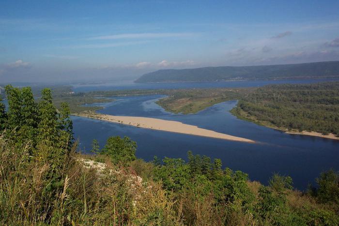
Rivers and seas of the East European Plain
Where the Russian Plain is located, there are many rivers and lakes. The main rivers playing a major role in economic activity people are the Volga, Oka and Don.
The Volga is the largest river in Europe. The Volga-Kama hydro-industrial complex is located on it, which includes a dam, a hydroelectric power station and a reservoir. The length of the Volga is 3631 km. Many of its tributaries are used by the economy for irrigation.

Don also plays a significant role in industrial activities. Its length is 1870 km. The Volga-Don shipping canal and the Tsimlyansk reservoir are especially important.
In addition to these large rivers, the following rivers flow on the plain: Khoper, Voronezh, Bityug, Northern Onega, Kem and others.
In addition to rivers, the Russian Plain includes the Barents, White, Black, and Caspian.
Along the bottom Baltic Sea The Nord Stream gas pipeline passes through. This affects the ecological situation of the hydrological object. During the construction of the gas pipeline, water became clogged and many species of fish decreased in number.
In the Baltic, Barents, and Caspian Seas, some minerals are extracted, which, in turn, has an adverse effect on the waters. Some industrial waste leaks into the seas.

In the Barents and Black Seas, several types of fish are caught on an industrial scale: cod, herring, flounder, haddock, halibut, catfish, anchovy, pike perch, mackerel, etc.
Fishing, mainly sturgeon, is carried out in the Caspian Sea. On the seashore due to favorable conditions natural conditions There are many sanatoriums and tourist centers. There are shipping routes along the Black Sea. Petroleum products are exported from Russian ports.
Groundwater of the Russian Plain
In addition to surface water, people use underground water, which, due to irrational use, has an adverse effect on soils - subsidence is formed, etc. There are three large artesian basins on the plain: the Caspian, Central Russian and East Russian. They serve as a source of water supply for a vast area.
The East European Plain is part of the East European Platform. This is an ancient and stable block bordering the In the east, the platform is framed by the Urals. The tectonic structure of the East European Plain is such that in the south it is adjacent to the Mediterranean pleated belt and the Scythian plate, which occupies the space of Ciscaucasia and Crimea. The border with it runs from the mouth of the Danube, along the Black and Azov Seas.
Tectonics
More ancient and hard Permian and Carboniferous limestones come to the surface on the banks of the Samarskaya Luka. Among the sediments, hard sandstones should also be highlighted. The crystalline foundation of the Volga Upland is lowered to greater depth(about 800 meters).
The closer to the Oka-Don lowland, the more the surface decreases. The Volga slopes are steep and dissected by numerous ravines and gullies. Because of this, a very rough terrain has formed here.

and Oksko-Donskaya lowland
General Syrt is another important component relief that distinguishes the East European Plain. Photos of this region on the border of Russia and Kazakhstan show an area of chernozem, chestnut soils and solonchaks, prevailing on watersheds and river valleys. Common Syrt begins in the Volga region and extends 500 kilometers to the east. It is mainly located in the area between the Big Irgiz and Small Irgiz rivers, adjoining the Southern Urals in the east.
Between the Volga and Central Russian Uplands is the Oka-Don Lowland. Its northern part is also known as Meshchera. The northern border of the lowland is Oka. In the south, its natural boundary is the Kalach Upland. An important part of the lowland is the Oksko-Tsninsky shaft. It stretches through Morshansk, Kasimov and Kovrov. In the north, the surface of the Oka-Don lowland was formed from glacial deposits, and in the south its basis is sand.

Valdai and Northern Uvaly
The vast East European Plain lies between the Atlantic and Arctic oceans. The basins of the rivers flowing into them begin at its highest point - 346 meters. Valdai is located in the Smolensk, Tver and Novgorod regions. It is distinguished by hilly, ridge and moraine relief. There are many swamps and lakes here (including Seliger and the Upper Volga lakes).
The northernmost part of the East European Plain is the Northern Uvaly. They occupy the territory of the Komi Republic, Kostroma, Kirov and Vologda regions. The hills consisting of hills gradually decrease in a northerly direction until they abut the White and Barents Seas. Its maximum height is 293 meters. Northern Uvaly is the watershed of the Northern Dvina and Volga basin.

Black Sea Lowland
In the southwest, the East European Plain ends in the Black Sea Lowland, located on the territory of Ukraine and Moldova. On one side it is limited by the Danube Delta, and on the other by the Azov River Kalminus. The Black Sea lowland consists of Neogene and Paleogene sediments (clays, sands and limestones). They are covered with loams and loess.
The lowland is crossed by the valleys of several rivers: the Dniester, the Southern Bug and the Dnieper. Their banks are characterized by steepness and frequent landslides. There are many estuaries on the sea coast (Dniester, Dnieper, etc.). Another recognizable feature is the abundance of sand bars. The Black Sea lowland is dominated by a steppe landscape with dark chestnut and chernozem soils. This is the richest agricultural granary.